Hurricane Erin becomes a Category 4 as it rapidly intensifies in the Atlantic
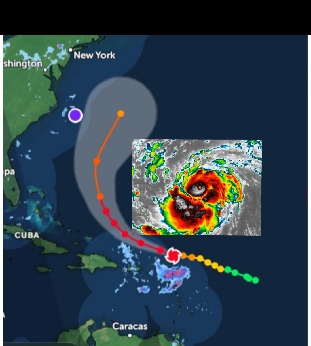
Hurricane Erin is the first major hurricane of the 2025 Atlantic season. The storm rapidly intensified overnight and is moving north of the Leeward Islands, U.S. Virgin Islands and Puerto Rico in the Caribbean.
Erin is expected to continue strengthening and may reach Category 5 status later today.
A hurricane is a type of tropical cyclone, a rapidly rotating storm system with a low-pressure center, strong winds, and heavy rainfall. Hurricanes form over warm ocean waters and derive their energy from the evaporation of water from the ocean surface.
The warm, moist air rises, condenses into clouds and rain, and releases heat, further fueling the storm. This process creates a cycle of rising air and inward-flowing winds that spiral around the low-pressure center, forming the characteristic “eye” of the hurricane.
As of the special 5:50 a.m. advisory, Erin was located about 150 miles east of Anguilla and had maximum sustained winds of 130 mph with a minimum central pressure of 948 mb.
The outer bands of Erin are expected to produce heavy rainfall through Sunday across the northern Leeward Islands, the Virgin Islands and Puerto Rico.
Rainfall totals of 2 to 4 inches, with isolated totals of 6 inches, are expected.
This would not only be dangerous for anyone entering the waters, but also for property along the coast, as erosion — especially along North Carolina’s Outer Banks — could be a serious threat. The Outer Banks and other parts of North Carolina could see waves of 8 to 12 feet, with other areas of South Carolina and Virginia possibly seeing waves reaching 6 feet next week.
Despite the threat of strong waves along the East Coast, a cold front pushing off of America’s coast is expected to keep Erin out to sea and will also bring below-average temperatures to the Northeast next week.
How long Erin tracks west before turning to the north will determine how close it comes to the East Coast and Bermuda as well as how widespread the impacts may be next week.
“Erin is forecast to slowly curve to the north as it continues to strengthen over the weekend. At this time, the storm is forecast to remain hundreds of miles off the East Coast,” DaSilva said.
A powerful offshore hurricane can produce massive and dangerous waves well away from its center.
“Beaches along the entire East Coast, from Florida to New England and Atlantic Canada, will likely experience rough surf and dangerous rip currents as Erin tracks north and eventually northeast,” DaSilva said.
If you maybe in the area the hurricane is headed towards please seek shelter immediately.